This week I was set the task of creating a large-scale piece of art using GPS location. Hugh Pryor and Jeremy Wood, the first to implement this technique of generating an art piece, were used as a source of inspiration. An example of their work is shown below.
My first thought was to stare at a map of my local area and ascertain whether, by using the roads/streets, I could plan a route that resembled an object. The image below showed this; an elephant’s head, which looks like the logo from the brand Evernote.
After some deliberation, I came to the conclusion that I needed to go back to ‘the drawing board’ and repeat the process due to being unhappy with the result. The image was not he most accurate (as shown) and I found the exercise a little troublesome, as nothing seemed to resemble an object, at least as I interpreted it, so an alternative method would be needed.
After doing some more research I found further inspiration from looking at an application called Serendiptor, created by Mark Shepard. This Application was based on plotting a route via GPS, from point A to point B, and it would display it with a map overlay. The application was more than just a map, it gave you the function of choosing different routes to the same location based on them being different from one another, no two routes were the same. The image below is an example of this.
 (Image source:http://www.vidafx.co.uk/blog/travel-app-of-the-week-serendipitor/)
An idea to circumvent my lack of creativeness when drawing an object with roads and streets, where my canvas was already dictated, then sprung to mind.
My thought: What if the object was abstract rather than a specific picture of an object or text?
Furthermore, if I was drawing an abstract piece, then it could take any shape I wished. I decided that starting and finishing at specific locations would be my only constraint, as my method of drawing would be left up to chance – by roll of a virtual dice on my phone and tracking the result.
The numbers rolled would influence my direction as follows; 1 or 2 = turn left, 3 or 4 = straight ahead and 5 or 6 = turn right. In the interest of not traversing miles of roads/streets I rolled the dice at a frequency of my choosing and walked in straight lines where possible. The hope was to go, roughly, in the direction I needed to, which payed off (luckily) although I did have to double back on myself on at least one occasion. The image and video below shows my route as tracked through GPS on my phone.
As displayed above, my path had been tracked and there was no specific pattern other than it being abstract, which was achieved. The green spot showed my start location and the red spot highlighted my finished location, the blue line was my tracked piece of art. I entitled this piece ‘A Dicey Walk’.
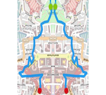
As part of additional works I experimented with my GPS drawing and realized that I could make another image. With the help of Adobe Photoshop, I found that if the image is mirrored and then flipped 180 degrees, there is a slight resemblance to a Christmas tree, thus meaning a created half of it, purely by chance and in an abstract manner.


