The word API is an abbreviation for ‘Application Programming Interface’. It is comprised of; protocols, routines and tools used for the constructing of software applications. From API information it is possible for web developers and programmers to extract relevant material and implement it within a Graphical User Interface (GUI). To simplify, it is how portable device applications are built upon gathered information and how the information gets presented to the user based on the application they have downloaded/installed.
With the development of portable device products becoming more user-friendly, it has enabled consumers to easily access and add their; personal details, behavioral habits, preferences etc. to a variety online services – contributing to the continuous growth of digital information a.k.a. ‘Big Data’. In addition, a sub component of big data would be the gathering of sensor readings which is why the term ‘Urban API’ was coined. Further more, this specific type of information being collected has led to the inception of ‘Smart Cities’.
Although Smart Cities are an entirely different topic altogether, it is important to recognize that Urban APIs are part of the foundation for the term. It has led to further development across the Digital Creative industry and web developers and programmers are generating new technologies to gain data as well as represent it for a city-wide digital network infrustructure. To illustrate the use of Urban APIs I have chosen to explain the Arch-OS system that has been integrated into the Portland Square building located on my university campus.
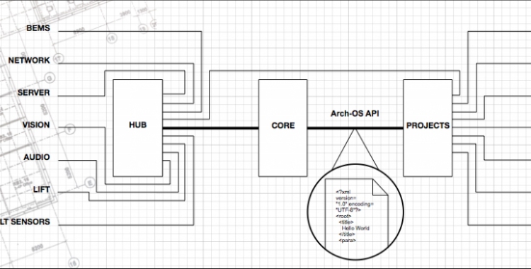
The Arch-OS System
(Image source: http://arch-os.com/system/)
The system is essentially a network of sensors that feed data into a hub, the creation of an API, so that you can present the results in a visual manner (as designed by a programmer/web developer). The system gathers a multitude of data sets, however, two worth noting are:-
- The flow of people and social interactions
- Environmental conditions
To help facilitate my explanation of Urban APIs further, I shall use the following example. Imagine if all buildings were fitted with this system in a city. An application could be designed to; represent the data of environmental conditions to give an accurate representation of the climate to citizens in real-time. Additionally, businesses could use the flow of people to monitor customer footfall, or monitor footfall across a city, i.e. more people heading towards a specific point of interest at this time, congestion in this area is likely, take this alternative route to avoid. The possibilities of gathering such information could have vast applications for use and equally so could the array of sensors being designed to retrieve it.

